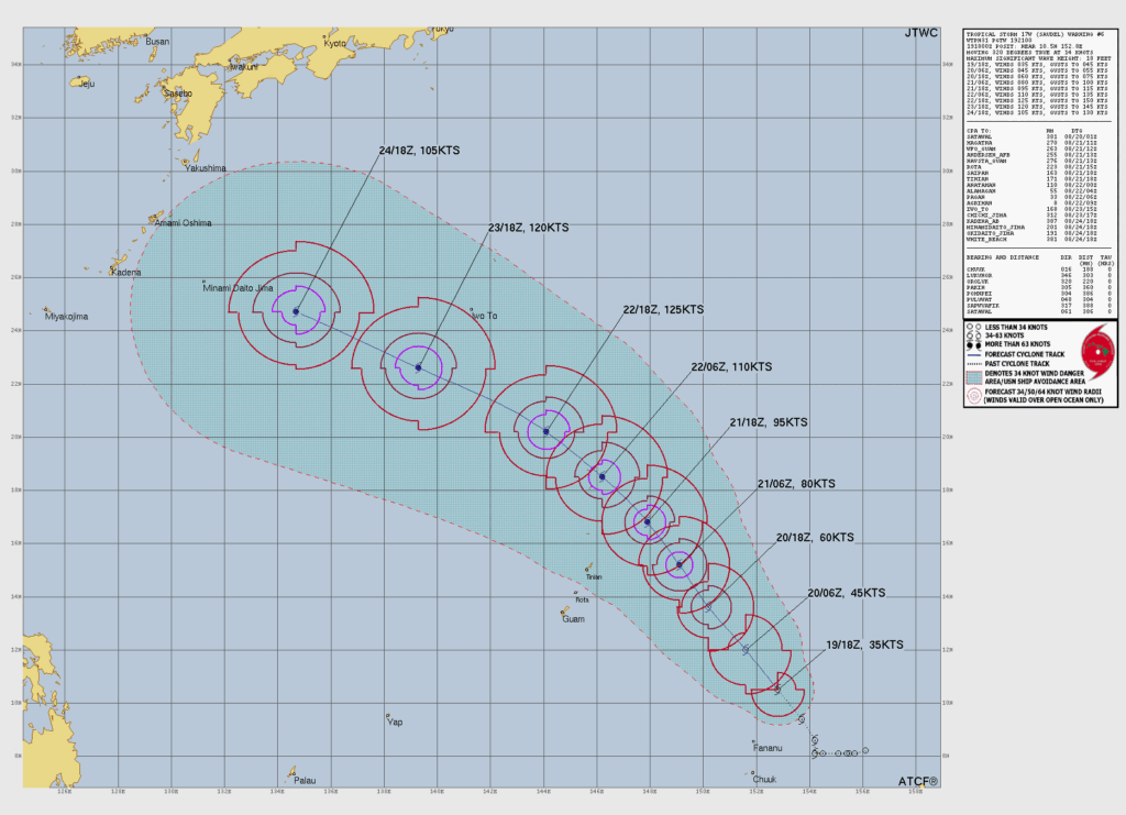

SAIPAN — Tropical Storm Saudel accelerated to 16 mph on a northwest track overnight, and the Joint Typhoon Warning Center said in its 7 a.m. Thursday warning that a period of rapid intensification is forecast to begin this afternoon and run through Friday, carrying the storm to typhoon strength as it approaches the Marianas.
As of 7 a.m., Saudel held maximum sustained winds of 40 mph with gusts to 52 mph, centered about 188 nautical miles north-northeast of Chuuk near 10.9N 152.5E. The storm remains poorly organized, forecasters said, with a partly exposed circulation center and most of its thunderstorm activity confined to its southern half, which is expected to slow strengthening slightly through this afternoon.
That changes once the system consolidates. The warning center forecasts rapid intensification from late this afternoon through Friday afternoon in what it called a highly favorable environment of warm sea surface temperatures near 30 degrees Celsius, high ocean heat content and low wind shear. Saudel is forecast to reach 70 mph by early Friday morning, cross the typhoon threshold Friday morning to midday and stand at 92 mph by Friday afternoon.
The forecast track carries the storm to about 127 mph as it passes just northeast of Pagan Saturday afternoon into Saturday night, reaching its forecast peak of 145 mph early Sunday northwest of the islands before gradually weakening, possibly through an eyewall replacement cycle suggested by hurricane model fields.
Track confidence remains high through Saturday night and is tightening, with model cross-track spread narrowing to 80 nautical miles at 72 hours and the five-day spread improving to 125 nautical miles. Two models run faster than the pack by about 125 nautical miles along the track; the official forecast sits near the multi-model consensus.
Maximum significant wave height near the storm has climbed to 18 feet. No tropical storm or typhoon watches or warnings are in effect for the Marianas as of Thursday morning, and the National Weather Service has urged residents to plan and prepare while conditions remain fair. JTWC warnings continue every six hours, with the next due at 1 p.m.