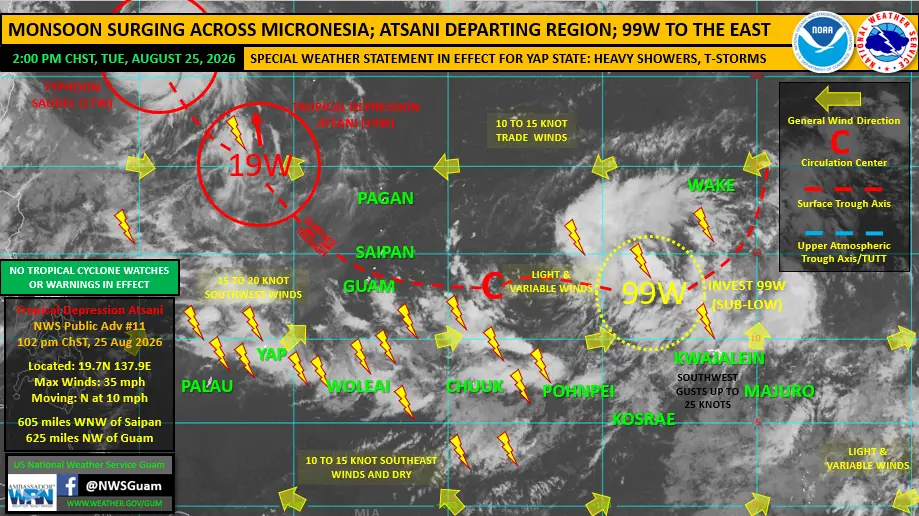

The National Weather Service Guam’s Weekly Regional Weather Outlook, issued Tuesday, August 25 at 2 p.m. and prepared by Warning Coordination Meteorologist Landon Aydlett, describes a busy, wet-season pattern holding across the western North Pacific, but no tropical cyclone watches or warnings for the Marianas.
Tropical Depression Atsani (19W) is in its waning stages well northwest of the Marianas. As of the 1:02 p.m. public advisory, Atsani was centered near 19.7°N 137.9°E, about 605 miles west-northwest of Saipan and 625 miles northwest of Guam, with maximum sustained winds of 35 mph, moving north at 10 mph. NWS Guam continues six-hourly public advisories as the system turns toward the northwest and, in the outlook’s words, soon meets its demise.
Typhoon Saudel (17W) will pass near or just north of Okinawa tonight as a category 2 typhoon. Saudel has exited the NWS Guam Area of Responsibility, passing north of 25°N.
Forecasters are also tracking a new tropical disturbance, Invest 99W, taking shape between Pohnpei and Wake Island near 13°N 163°E. The Joint Typhoon Warning Center rates its development potential as “sub low,” and 99W is not expected to develop in the coming days. The outlook calls it something to watch later this week, but current trajectories indicate no threat to the Federated States of Micronesia or the Marianas as it eventually heads generally north.
An active monsoon pattern persists along and south of 10°N, covering all of the FSM and the northern Marshall Islands. Heavy showers and thunderstorms were ongoing Tuesday across Yap, where more than 22 inches of rain fell in the last week. A Special Weather Statement is in effect for Yap State, and forecasters warn heavy showers could trigger additional mudslides and localized flooding on high islands. Last week’s heavy rain produced several small landslides in Chuuk and Kosrae, damaging at least one home in Kosrae. Palau and Kapingamarangi remain the regional dry outliers.
The outlook notes additional tropical disturbances are to be expected as conditions remain active across the basin, and reminds readers that tropical disturbances are not guaranteed to develop into tropical cyclones.