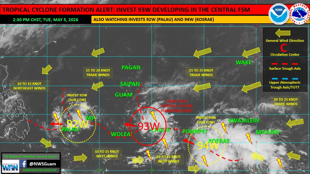
SAIPAN — A tropical disturbance designated Invest 93W has been placed under a Tropical Cyclone Formation Alert by the National Weather Service Guam, but does not pose a direct threat to the Marianas, the agency said in its weekly Regional Weather Outlook issued Tuesday afternoon.
The system was located about 130 nautical miles west of Chuuk Lagoon as of 1:30 p.m. Tuesday and is tracking generally westward in a favorable environment for development. The TCFA designation indicates the system could become a tropical depression within 24 hours, NWS said.
NWS is also tracking two other disturbances. Invest 92W is centered near Palau and Invest 94W is centered southwest of Kosrae, both rated sub-low for development. Significant development is not expected for either system in the coming days, the bulletin said.
In the Marianas, a breezy trade wind pattern persists and will continue through the weekend. As 93W passes south of Guam over the next few days, additional showers are expected for the southern Marianas tonight through early Thursday, NWS said.
Large trade wind swell will generate combined seas of 6 to 9 feet and surf up to 10 feet through the period, with a high risk of rip currents along east-facing reefs and beaches, the agency said.
Forecasts for Palau and the Federated States of Micronesia will be dominated by the three disturbances tracking westward through the region. The Marshall Islands are expected to see a showery trade wind pattern as surging trades converge into the eastern periphery of 94W.
NWS said abnormally dry conditions persist across Palau and western Yap State. The active pattern across the region south of 10 degrees north could continue to bring much-needed rainfall to drought-affected islands and atolls, though rainfall is not guaranteed at any given location.