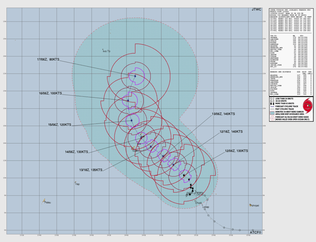
SAIPAN — The latest track chart from the Joint Typhoon Warning Center shows Typhoon Sinlaku on a direct path toward the Marianas and forecast to reach super typhoon strength before landfall, with the storm’s center projected to pass over or near Rota, Tinian and Saipan as early as Tuesday morning.
The JTWC chart, issued Sunday evening, shows the storm at 130 knots (approximately 150 mph) with a forecast intensity of 140 knots, or about 161 mph, by Sunday night. That would place Sinlaku at super typhoon strength, the western Pacific equivalent of a Category 4 or stronger hurricane on the Saffir-Simpson scale.
The track projects the center passing through the Marianas island chain between Tuesday morning and Tuesday evening at sustained winds of 135 to 140 knots before beginning to weaken and curve northwest. Rota is shown approximately 125 miles from the current storm center, with Saipan at approximately 18 miles in the bearing and distance table on the chart.
The storm is expected to maintain near-peak intensity as it moves through the island chain before gradually weakening through Wednesday and into Thursday, when forecast winds drop to 100 knots near the 16th parallel and 80 knots by Thursday morning.
HSEM Bulletin 6A, issued at 5 p.m. Sunday, placed the storm at 125 mph with a Typhoon Warning in effect for Saipan, Tinian and Rota. Typhoon-force winds extend 60 miles from the center. Residents should expect conditions to deteriorate rapidly beginning Monday evening and are urged to be in their shelter or safe location before dark Monday.
The CNMI EOC State Warning Point can be reached at 670-237-8000 or 670-664-8000. The next HSEM bulletin was scheduled for 8 p.m. Sunday.