SAIPAN — The National Weather Service issued a supplemental outlook Thursday on a tropical disturbance southwest of Chuuk that forecasters say could bring heavy rainfall, elevated surf and breezy winds to the Northern Mariana Islands this weekend.
The update on Invest Area 95W comes midweek as conditions warranted additional guidance beyond the service’s regular Tuesday regional weather outlook.
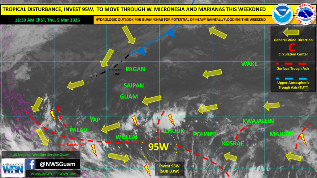
Invest 95W, located within the near-equatorial trough, is rated “sub low” for development by the Joint Typhoon Warning Center, meaning significant strengthening into a tropical depression is not expected in the coming days. The system’s circulation center remains poorly defined and convection disorganized.
The disturbance is moving slowly west-northwestward and is forecast to remain broad and disorganized. The primary uncertainty, according to forecasters, is whether 95W will merge with a shear line expected to move into the Marianas this weekend or slide south toward Yap and Palau as a separate feature.
Should the system interact with the shear line, the CNMI and Guam could see heavy rainfall with flash flooding potential, elevated seas and surf, and breezy conditions with stronger gusts in heavier showers and thunderstorms beginning late Friday and continuing through early next week. A Hydrologic Outlook has been issued for both jurisdictions. A High Surf Advisory and Rip Current Statement has been extended through Monday afternoon.
For Yap State and Palau, forecasters said uncertainty is higher but an unsettled weather pattern is expected, with surf increasing along north-facing reefs this weekend.