SAIPAN — The Marianas are in for a stretch of drier weather through Friday after heavy rainfall moved across the islands Monday, but forecasters are warning of increasing winds, building seas, and a higher chance of heavy showers and thunderstorms by the weekend.
The National Weather Service in Guam, in its weekly regional outlook issued Tuesday, said a weakening shear line fragment was responsible for Monday’s heavy rain. Drier conditions are expected to hold through Friday before conditions deteriorate.
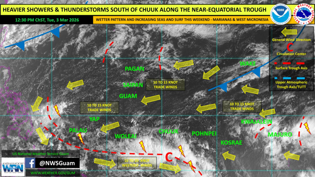
Two weather systems are expected to converge on the region by the weekend. A disturbance is forecast to develop within the near-equatorial trough south of Chuuk and shift west-northwest, while a cold front moving southward from a low pressure system off the east coast of Japan is expected to transition into a shear line. Together, the two features are expected to increase winds across the Marianas, build seas and surf, and raise the potential for heavier showers and thunderstorms.
In the meantime, seas of 5 to 7 feet and moderate trade winds are expected through at least Thursday. A high risk of rip currents remains in effect along east-facing reefs and beaches through Tuesday afternoon. Beachgoers and ocean users are urged to exercise caution.
Higher tides are also expected over the next few days following the Full Moon phase.
There are no tropical cyclone threats or areas of active development within the NWS Guam area of responsibility. However, forecasters are monitoring the Madden-Julian Oscillation, which is expected to propagate eastward into the western Pacific over the next couple of weeks. That pattern can favor tropical cyclone development in the West Pacific and will be watched in conjunction with the disturbance expected to form within the near-equatorial trough.
On drought, the Marianas and most of the broader region continue to see near to above-normal rainfall. Drought conditions remain concentrated in the northern Marshall Islands, where Utirik and Wotje are experiencing severe drought.
For Guam, conditions mirror those of the CNMI, with drier weather expected through Friday before the weekend pattern brings increased wind, seas, and rainfall potential.
Patchy showers and isolated thunderstorms are affecting areas near Palau and Yap, with a developing disturbance expected to move toward those islands this weekend, potentially bringing gusty winds and locally heavy rainfall along with a northerly swell and elevated surf. Scattered showers are also extending across portions of Chuuk and the Marshall Islands.