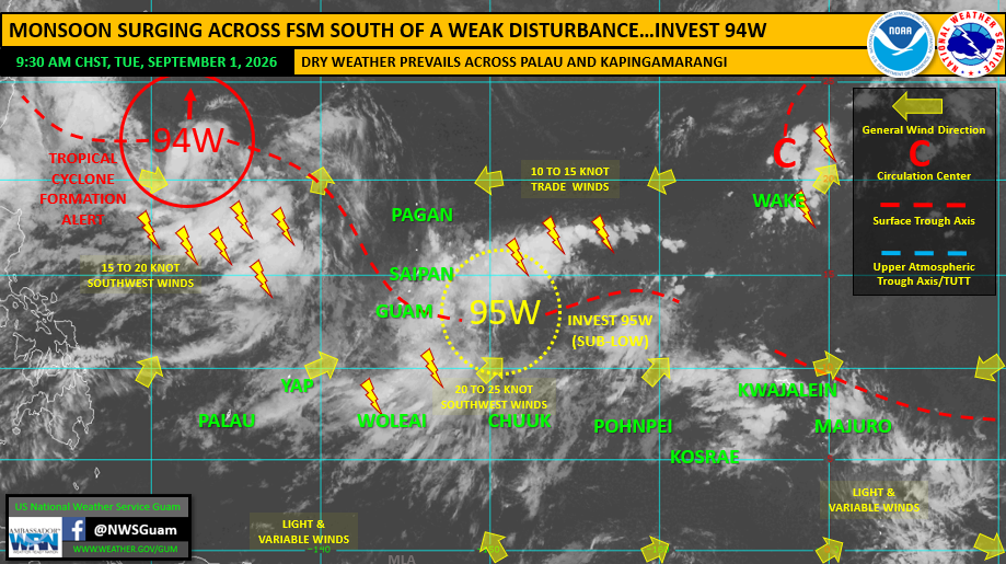

SAIPAN — Two tropical disturbances are on the western Pacific map this morning, and the National Weather Service’s weekly regional outlook draws a clear line between them: the system under a formation alert poses no threat to the Marianas, while the one expected to pass near or through the islands later this week is likely to remain a disturbance rather than develop.
Invest 94W, well northwest of the Marianas, remains under a Tropical Cyclone Formation Alert from the Joint Typhoon Warning Center, meaning it is likely to become a tropical depression within 24 hours. It poses no threat to the Marianas or any island of Micronesia as it tracks generally northward, the outlook states.
Invest 95W, centered just east of the Marianas, is rated “sub low” for development, meaning development is not expected in the near term. The system will track generally northwestward near or through the Marianas, possibly the NMI, later this week — most likely as a developing tropical disturbance rather than a tropical depression or tropical storm, according to the outlook, prepared by Warning Coordination Meteorologist Landon Aydlett. As 95W nears, the stronger southwest winds along its southern periphery will pass over Guam and the CNMI with a wetter pattern mid to late week, a mix of showers locally heavy at times, and building seas and surf.
No watches, warnings or advisories are in effect. Forecasters note conditions can change quickly and urge residents to stay current with forecasts at weather.gov/gum.
To the south, the monsoon surge continues across Yap and Chuuk states through Wednesday with gusty southwest winds and locally heavy rain, while Palau’s abnormally dry stretch persists.