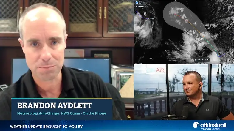

SAIPAN — Tropical Depression 17W’s long-anticipated turn to the northwest may be happening right now, and the current forecast track is focused on the CNMI’s far northern islands this weekend, perhaps as close as Pagan, the National Weather Service’s top meteorologist on Guam said Wednesday morning.
“Right now, 7 o’clock this morning, the forecast track number two, it does reflect a west-northwest motion of six miles per hour. That could be that turn taking place right now,” Brandon Aydlett, meteorologist-in-charge at NWS Guam, said in an interview on Good Morning Marianas. “Once that happens and we’ve got a definitive northwest motion, we’re going to start seeing that potential range of track is going to start to solidify around the common theme. That right now it is focused in the far northern islands for this weekend, perhaps as close as Pagan Island.”
Aydlett said forecasters want to see the definitive northwest motion, expected to be well defined within the next 12 to 18 hours, before narrowing the eventual outcome. No tropical storm or typhoon watches or warnings are in effect for the Marianas, and the weather service issues them as early as 48 hours before the onset of tropical storm conditions.
“We’ve still got a little bit of wiggle room. We’ve still got a couple more days to watch, to see 17W lift out of Chuuk State,” he said. “Right now is the time to watch, to monitor, and know where to get the most up-to-date information.”
Aydlett walked through Tuesday’s rapid escalation, from a low development rating to a tropical depression in roughly 12 hours. Midday satellite data showed a coherent, well-rounded circulation, prompting the Joint Typhoon Warning Center to raise the system to medium, then to a formation alert in the evening and the declaration of Tropical Depression 17W before midnight.
He cautioned again against reading single model runs, including one he showed Tuesday night depicting a strong typhoon passing northwest of the far northern islands Sunday afternoon. The ensembles, the multiple variations of a single track, show spread east and west, north and south, and in timing, he said, with that variability inevitably decreasing as the system enters the four-to-five-day range.
The forecast collides directly with Saturday’s rescheduled Liberation Day parade, set for 10 a.m. along Quartermaster Road after Super Typhoon Bavi washed out the original celebration.
“Nature has a way of liking to rain on parades. There’s a reason for that saying,” Aydlett said. “That’s going to be one of those tough conversations we’re going to be having in the next day, today, tomorrow, for the decision makers up there to kind of look at the plans and the timing. So we’re going to be taking a close look at the weather conditions, trying to get the best, most accurate forecast to the folks up there so they can make the best decision.”
For the lower Marianas, Aydlett said drier, more pleasant conditions could hold Thursday, Friday and possibly into Saturday before southwest winds pick up Sunday, a pattern forecasters may call a southwest monsoon tail blowing into the tropical cyclone. Late weekend into early next week could bring periods of heavier showers, stronger and gustier southwest winds and increasing chop on the waters, he said, even without a direct hit. Wednesday morning’s wet weather across the lower Marianas is unrelated to 17W, he added, the product of a convergent flow in the surrounding pattern.
The weather service’s local statement, which details suggested preparation actions and impact timelines, currently covers Chuuk and Pohnpei states and some outer islands. As the system approaches, Aydlett said, forecasters would anticipate adding the far northern islands of Agrihan, Alamagan and Pagan based on the current track, while watching for any potential increase in risk for Saipan, Tinian, Rota or Guam.
“Be ready to take actions as needed in case we see a southward shift in the forecast track, in case that threat intensifies for the lower islands,” he said.
Public tropical cyclone advisories are being issued every six hours, at 2 and 8 in the morning and evening, with the track updated in each and the next advisory due at 2 p.m. Wednesday. If watches or warnings are posted anywhere in the weather service’s area of responsibility, advisories move to every three hours. The office has expanded shifts and is running 24-7, Aydlett said. Forecasts are posted at weather.gov/gum and weather.gov/gum/cyclones.
Aydlett noted the season is delivering on El Niño expectations that fell short in 2023, with four-plus months of 2026 still to go. “We can get tropical cyclones any time of the year, even more so in the wet season,” he said, urging households, offices and businesses to keep preparation plans ready.