SAIPAN — National Weather Service meteorologist-in-charge Brandon Aydlett and lead forecaster Joshua Schenck delivered a sobering Facebook Live briefing Saturday afternoon, confirming that Typhoon Sinlaku is now forecast to arrive at Guam with 140 mph sustained winds and gusts up to 170 mph, conditions comparable to Typhoon Mawar in 2023, while a Typhoon Watch is now in effect for all four Marianas islands including Guam, Rota, Tinian and Saipan.
The watch, which means typhoon-force winds of 74 mph or more are possible within 48 hours, was expanded to cover all of the Marianas as the storm’s track has remained persistently aimed at Guam. As of the 1 p.m. advisory, Sinlaku was located about 90 miles northwest of Chuuk Lagoon with maximum sustained winds of 85 mph, moving slowly north-northeast at 5 mph. The system is expected to curve northwest through tonight before accelerating toward the Marianas.
Aydlett said the earliest reasonable arrival time of tropical storm-force winds for the Marianas is Monday at 8 a.m., with the most likely arrival time Monday evening.
“Sometime Monday, Monday midday, we should be seeing those tropical storm conditions arise on Guam,” Aydlett said. “Any little northward shift in the track, just a small shift, will bring a greater risk of typhoon conditions for Tinian and Saipan.”
Typhoon-force wind probabilities have climbed in the past six hours. Guam now sits at 40 percent, up from 30 percent earlier in the day. Rota is at just over 30 percent, up from just under 30. Tinian and Saipan remain at 10 to 20 percent.
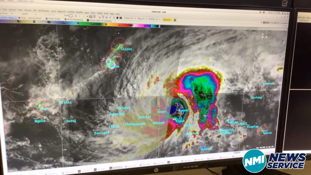
Schenck described the storm’s wind field as extensive. Tropical storm-force winds extend up to 185 miles from the center and are expected to persist across most of Chuuk State for at least another 24 hours, with some areas not seeing improvement until Sunday evening. The island of Fananu is currently under a typhoon warning and is likely experiencing low-end Category 1 conditions.
Aydlett described what Category 3 and 4 conditions would mean for the Marianas in detail. At Category 3, light material structures could be destroyed, non-reinforced concrete walls could be blown down and light vehicles could be overturned. At Category 4, homes of light materials could be disintegrated, roof structures could see complete failure and heavy airborne debris would be a significant threat. He advised residents in concrete homes to stay away from windows even with shutters closed.
The briefing also highlighted the extreme rainfall Chuuk has already experienced. Satellite-derived estimates show some small areas receiving around 30 inches of rain, largely because the system was nearly stationary for 24 hours. Mudslide risk across steep terrain in Chuuk State remains high.
Polar orbiting satellite imagery received directly at the NWS office showed the eye of Sinlaku gradually beginning to take shape, with spiral banding indicative of a strengthening typhoon.
The next Joint Typhoon Warning Center forecast track update is at 7 p.m., followed by an NWS public advisory at 8 p.m. NWS is now issuing Marianas forecasts on a six-hour rotation, with updates at 9 p.m. and 3 a.m. Full forecast information is available at weather.gov/gum.
Watch the full video on the NMI News Service Facebook page and YouTube channel.